
| Project Information |
| History |
| Mainstreeter |
| Churches |
| Scholasticate |
| Schools |
| Railways |
| Notables |
| After 1907 |
| 1901 Snapshot |
| Air Photo Study |
| Image Library |
| Databases |
| Search |
|
1901 Snapshot continued
|
|
|
The Setting: The centre of the village was of course the town hall that had been built
under the direction of James Ballantyne in 1895. He lived across the street
at 54 Main in a large |
 |
 |
 |
| And just a few meters south on Main was Ardagh Square, the family home of the Grahams. The late John Graham owned hotels in Ottawa (The Albion) and the brickyard at the end of Clegg St. These families were, for the most part, the most influential in the village and all lived within a short distance of the town hall. | ||
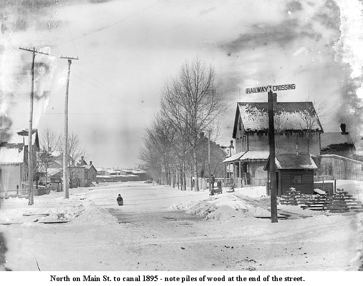
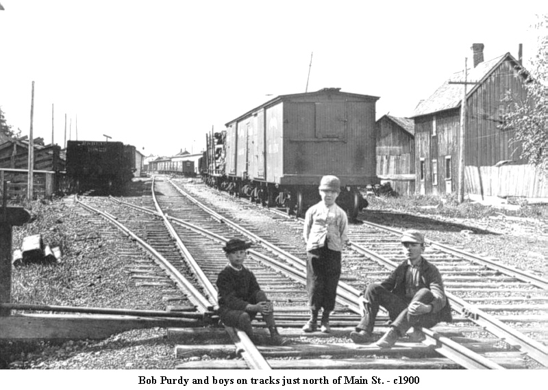
| Immediately to the north of this center point was a nearly impenetrable barrier - J. R. Booth's Grand Trunk Railroad. These tracks sliced the community into three separate parts, much as the Queensway does today. From Hurdman Bridge to the canal there was only one official crossing - at Main. Given the large amount of traffic on this GTR line at this point, a flagman and kiosk was installed to assist traffic and pedestrians. Purdy was the flagman at this time and photographs show a pleasant plump man in his sixties surrounded always by kids. To village children, Purdy's little house was the center of the universe. | ||
 |
 |
 |
 |
 |
 |
|
The village council had tried for years to force Booth to build a proper crossing at the end of William St (Lees) so as to allow unhindered travel to the north-eastern part of the village (Robinson Ave.). As one of the richest men in Canada, Booth was a formidable adversary. As the story goes, he built the Ottawa East rail line next the Lees property to destroy the quiet and isolation of Wildwood. Whatever his reason, after he built the line in 1882, he and Robert Lees battled ever after. |
||
Without the crossing on William, the tiny enclave centered
on Robinson Ave. was virtually cut off. That  isolation
continued up to the end of the Twentieth Century when better roads and bridges
were built. Even today (2004) residents of this area still identify more
with Sandy Hill that Ottawa East. The rail lines were also the very reason
the village existed. About 20% of the employed adult males in the village
worked for the railways, in particular the Canada Atlantic. Most of the
village industry was completely dependent on rail transport as it brought
the coal and vast quantities of raw and finished wood and shipped out the
bricks. Further isolating Robinson Ave. was the vast array of lumber and
coals sheds and stack of wood along the tracks. The only commercial activity
in the area other than this was the slaughterhouse at the end of the street
on the bank of the Rideau River. The river was the key here. Think of all
the entrails that daily emanates from an abattoir and then wonder where
this material was dumped! isolation
continued up to the end of the Twentieth Century when better roads and bridges
were built. Even today (2004) residents of this area still identify more
with Sandy Hill that Ottawa East. The rail lines were also the very reason
the village existed. About 20% of the employed adult males in the village
worked for the railways, in particular the Canada Atlantic. Most of the
village industry was completely dependent on rail transport as it brought
the coal and vast quantities of raw and finished wood and shipped out the
bricks. Further isolating Robinson Ave. was the vast array of lumber and
coals sheds and stack of wood along the tracks. The only commercial activity
in the area other than this was the slaughterhouse at the end of the street
on the bank of the Rideau River. The river was the key here. Think of all
the entrails that daily emanates from an abattoir and then wonder where
this material was dumped! |
||
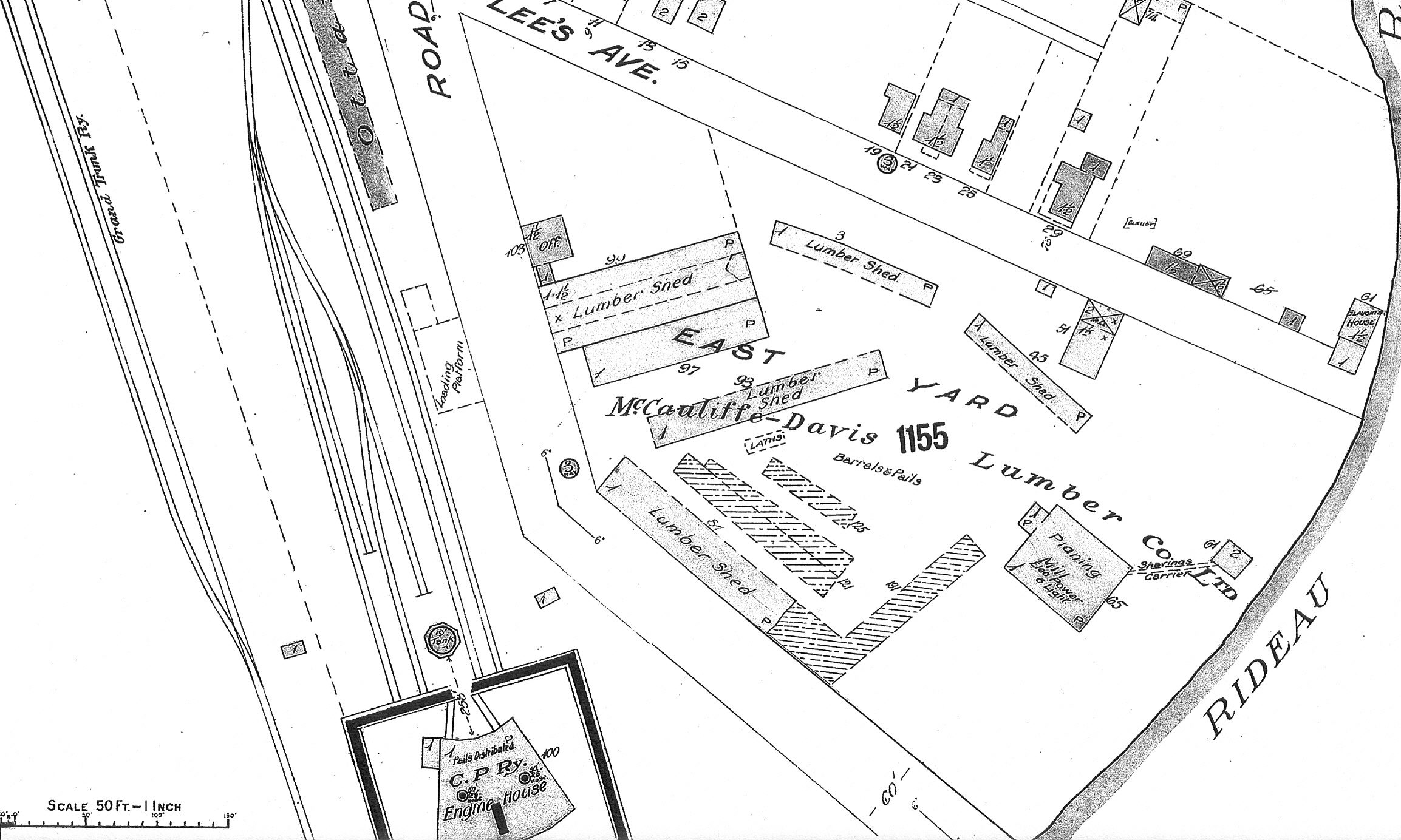
| The Fire Insurance Maps here show the isolation of this community by the rail lines and lumber sheds | |||||||
 |
 |
||||||
|
From this point southwest to the "Deep Cut" where the canal takes a sharp left-hand turn, was the "round house" complex. This was huge circular building in the center of which was a turntable that allowed engines to be turned and directed in to repair slots. This area employed hundreds of people who repaired and serviced the equipment as well as shunting a never-ending amount of coal, wood and a myriad of other material around the rail yard. There is much more on the railway's activities here.
|
|||||||
|
The triangle had the only church and the only school. Trinity Anglican
(later Ascension) was utilised by most
|
|||||||
The only bridge connection to Ottawa was located at Cedar
St. (Harvey projected) across the canal to Argyle Ave. at Cartier. Built in 1890, this iron and wood swing bridge provided
the need access to city markets and jobs. It however, could not manage heavy
traffic such as wagons loaded with brick or the new trolley that came to
the end of Elgin St. Ottawa Easters still had to trudge across in subzero
weather to access public transport. A portion of the bridge
Argyle Ave. at Cartier. Built in 1890, this iron and wood swing bridge provided
the need access to city markets and jobs. It however, could not manage heavy
traffic such as wagons loaded with brick or the new trolley that came to
the end of Elgin St. Ottawa Easters still had to trudge across in subzero
weather to access public transport. A portion of the bridge can be seen here on the Fire Insurance Map. |
|||||||
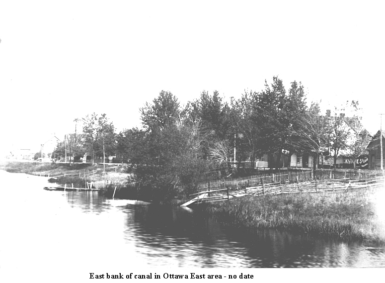
Across Seventh St. (Hawthorne), along the bank
of the canal, the diversity continued. The waterway was used by numerous
pleasure craft (mostly row boats and canoes) and provided numerous transshipment
points for everything from sand to coal to wood. W. E. Beaton, a leader
of the Baptist Church, village councillor and merchant, operated a wood-fuel
yard at Clegg and the canal.
|
|||||||
| Patterson's field was the largest garden plot between the canal and Main (later St. Pat's College and then Immaculata). The streets between Gordon (Hazel) and Clegg continued to draw new residents, most of who built their own homes. | |||||||
| Across Main from Seventh (Hawthorne) to Victoria (Springhurst) it was mostly residential interspersed with local businesses. The major industry was the O'Dell brickyard located at the end of William St. (Lees) approximately where Simcoe St. is today. Horace O'Dell made extensive use of the sand and clay deposits along the Rideau River at Springhurst. A rail spur was built from the CPR line directly into his factory. | |||||||
Adjacent and south was the Scholasticate (Deschâtelets),
the center of the Oblates of Mary Immaculate  (OMI).
This was a sprawling complex of about 30 acres, set far back from Main St.
For the most part it was separate from village life in that the Oblates
were self-contained with their own extensive vegetable gardens, livestock
and poultry supplies. But they were also the leaders of the Catholic community
and played the major role in the establishment of the Ste. Famille parish
and Catholic schools. There is much more on this complex story found
here. (OMI).
This was a sprawling complex of about 30 acres, set far back from Main St.
For the most part it was separate from village life in that the Oblates
were self-contained with their own extensive vegetable gardens, livestock
and poultry supplies. But they were also the leaders of the Catholic community
and played the major role in the establishment of the Ste. Famille parish
and Catholic schools. There is much more on this complex story found
here. |
|||||||
|
South of the Oblates were the extensive farms of the Williams and Slattery
families and the Graham Brickyard That was the 1901 setting of the village - few major industries, a railway complex, inexpensive housing and lots of agriculture. It was the people who made it work. |
|||||||


