
| Project Information |
| History |
| Mainstreeter |
| Churches |
| Scholasticate |
| Schools |
| Railways |
| Notables |
| After 1907 |
| 1901 Snapshot |
| Air Photo Study |
| Image Library |
| Databases |
| Search |
|
Air Photo Study |
|
| The difficulty in writing the modern history of Ottawa East lies in the difficulty finding records. Thank God for the churches! Not only did they keep a written history but also preserved some valuable photographs. Modern pictures are hard to come by given that most people don't realize the treasure in that old box under the bed. Fortunately, we do have an excellent record in the air photos stored at the National Air Photo Library here in Ottawa - a major plus for this project. | |
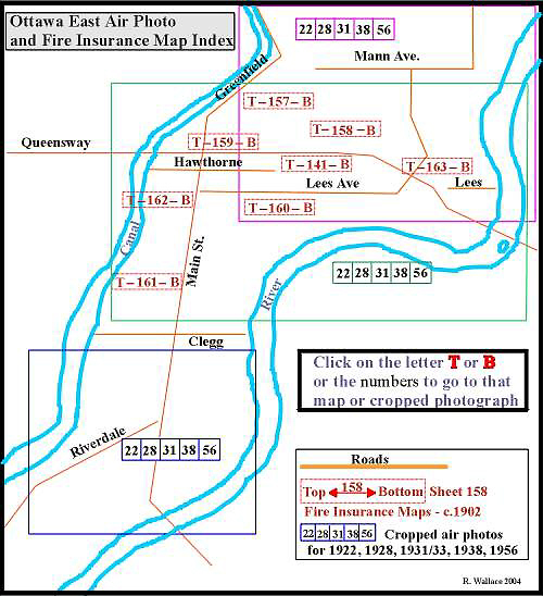
| Below is an index map of the Ottawa East area. The map shows the location of the air photos and the Fire Insurance Maps explained here. Ottawa East has been divided into 3 parts: North, Central and South. In each part there are a series of rectangles with the numbers 22, 28, 31, 38 and 56. These correspond to the years 1922, 1928 and so on. If you carefully click on the exact number the link will take you to the specific photograph for that year which in some cases is cropped and expanded for your viewing pleasure. If this is all confusing then just click all over the map below and you'll get the idea. | |
| Of major importance to the entire photographic collection found on this CD-ROM is the oblique air photograph taken in 1922. It is so important that a separate page has been designated to explain how the image was obtained and its significance to the history of Ottawa East. That page is found here. Don't miss it! | |
| Remember that each of the picture references shown on the index map below are for that specific year. There are other air photos in the Image Library found here. To gain more flexibility the reader may wish to load the images in the Air Photo section in a more powerful image viewer. Identify the photograph by the cue card then search in the Air Photo Library. And you could always go here to see a Slide Show of all air photos. For some suggestions on how to study the photographs go here. | |
| The 1956 Fire Insurance Maps can be found here. | |
| And if all of the above is too confusing, here is a hotlinked index of all the air photos by year | |
| 1922 | H_5_1922_clr_oe |
| 1928 | |
| 1931 | A3332_43_1931 | A3332_67_1931| A3332_68_1931 | A3332_69_1931 |
| 1933 | A4569_35_1933 | A4569_36_1933 |
| 1938 | A6532_36_1938 |
| 1956 | A13507_459_1956 | A13507_460_1956 |
| Various |
X_St. Pat's_Air_1935
| X_rideau
garden 1956 | X_rideau
garden 1938 |
