
| Project Information |
| History |
| Mainstreeter |
| Churches |
| Scholasticate |
| Schools |
| Railways |
| Notables |
| After 1907 |
| 1901 Snapshot |
| Air Photo Study |
| Image Library |
| Databases |
| Search |
|
Ottawa East's Earliest
Air Photograph
|
|
|
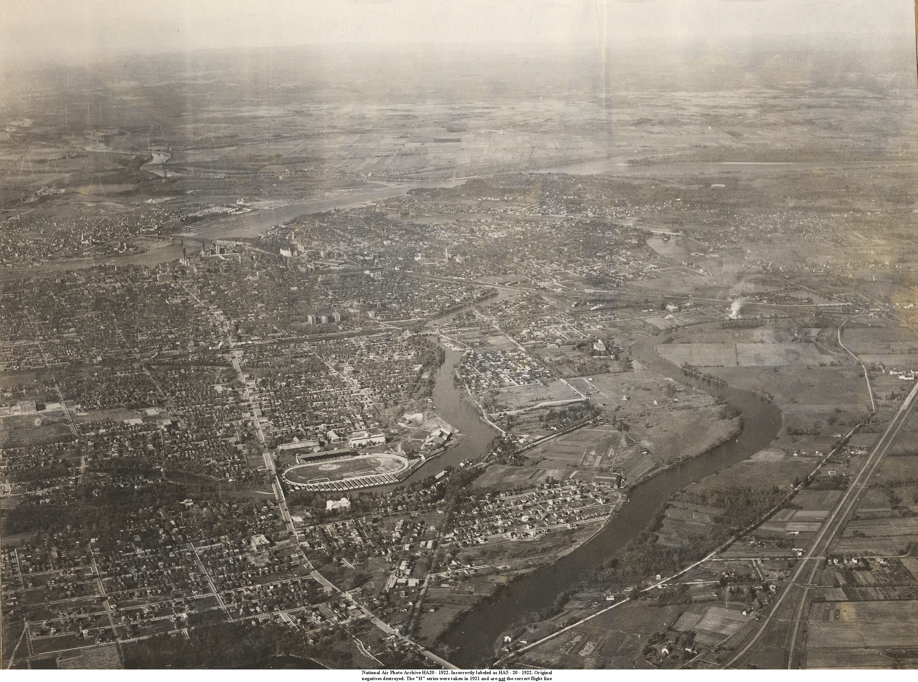
Every now and then, when doing research such as this, one encounters a treasure that in the end makes the effort worthwhile. The photograph below is an example. Taken in 1922, from a "Flying Boat" (an amphibious aircraft), it is one of the earliest air photographs taken of the Ottawa area. From my research it appears that it is the earliest one ever in terms of Ottawa East. It must be remembered that this was a time of infancy not only for human flight but also aerial photography. The way the story goes (an unsubstantiated story at present), the Canadian Air Force was attempting to demonstrate the usefulness of aircraft to the military and therefore the government. During this time several flight lines were made over the Ottawa area and up the Gatineau River, sequentially photographing the landscape from the air. This photograph is supposedly a result of this activity. In researching the history of Ottawa East as seen through the earliest air photographs I spent many days in the National Air Photograph Library on Booth St., here in Ottawa. After hours of hauling large metal boxes of glossy photos to the desk with the stereoscopic viewer I happened to ask one of the library workers if perchance, there were other very old photos stored elsewhere. She said that it was unlikely, so I moved on to other things. About an hour later she returned and mentioned that she did remember some old scrapbooks piled in the bottom of a locker in an area not open to the public. Off we went and sure enough, at the bottom of a very dusty gray metal locker, were some very old scrapbooks. If you understand the concept of "serendipity" then you will appreciate what happened next. Had I not asked the question, the photograph would have been missed. The book contained about 30 of the most amazing oblique photographs I have ever encountered. When I turned to #20 I think my heart skipped a beat. There before my weary eyes was 1922 Ottawa East (and more), in excellent resolution. The photo was part of the "H" series, one of the oldest at the library. Subsequent research showed that the original nitrate negatives had been destroyed and as yet, no record has been found of the actual flight line or date. The number on the photo is HA5 - 20 - 1922 and this is incorrect. That flight line was taken in 1921 and does not cover the Ottawa Area. The correct number is HA - 20 - 1922. Given that the original negatives had been destroyed (nitrate film has a tendency to catch fire), I had the photograph scanned at the highest resolution available. The image, delivered on CD-ROM, was over 6,000 pixels wide, 800 dpi and over 75 megabytes. When loaded in powerful imaging software I could blow it up to over 400% without losing much of the quality. And what is revealed is a time capsule - fixing a point in the history of the community. You can see a steam engine chugging along the tracks, the infamous incinerator at the end of Lees Ave., the lonely 'Stone Gates" at the entrance to Brantwood Place with only a couple of houses - hell you can even see a dog barking on Clegg Street! At this point many of you are probably wondering if this writer "has a life". I can only reply in comparison, that there are those, for example, who consider chasing a little white ball around manicured lawns in pseudo forests to be worthwhile endeavour. Happiness to this writer is finding treasures that may be lost to time and writing self-indulgent comments about the activity. But hey - the CD is free! And now, on to the picture. The very best way of viewing this remarkable
photograph is to load it into your imaging software. This will allow you
to manipulate the resolution, contrast and other attributes. You will
find the image (OTT22_3000pix.jpg) at 3,000 pixels in width and about
5.3 megabytes located at the end of this path: You can also find a 7.3 megabyte version here. The version shown just below is 1,000 pixels wide. Click anywhere on the photo and your browser will bring up the 3,000 pixel wide version. In some cases, such as Netscape 4.7 (time to upgrade!) this may start up your imaging software by default. And depending on your screen resolution and monitor, you may have to scroll a wee bit. North points to the upper right hand corner of the photo. The Exhibition Grounds are in the bottom left-center. Find the "Deep Cut" (where the Canal turns sharp left), Pretoria Bridge and the Scholasticate. Main Street is between these points running northwest to southeast. Whatever happens, spend some time with this treasure. It is a fascinating
view of the early community. |
|
 |
| And for those keen enquiring minds who may have noticed a similarity to the CD label, you would be correct. |