
| Project Information |
| History |
| Mainstreeter |
| Churches |
| Scholasticate |
| Schools |
| Railways |
| Notables |
| After 1907 |
| 1901 Snapshot |
| Air Photo Study |
| Image Library |
| Databases |
| Search |
|
Lees Avenue - Gas,
Tar and Garbage
|
| The annexation of Ottawa East in 1907 was a prelude to the creation by
the city of an industrial and waste complex at the end of Lees Avenue. As
detailed in Chapter Six, the city wanted this land to be the centre of future
commercial development that connected to the railways adjacent. Another
advantage of this location was the prevailing winds that blew from west
to east of the city proper. Any pungent odours would simply blow away from
the city.
Within a decade a massive gasification plant, tar works, incinerator
and landfill had been established along Lees Ave. Coupled with the daily
discharge of the adjacent slaughterhouse into the river, this "industrial
park"" soon became a major source of environmental contamination
which lingers even today. For nearly fifty years the tallest structure in Ottawa East was a massive
steel girder frame, about ten stories high. Situated at the end of Hawthorne
Ave. just east of Lees, this was the main storage tank for the coal gas
produced by the Ottawa Gas Company originally owned by the Ottawa Gas
and Electric Company. The plant complex was situated between the tank,
Lees and the railway lines. |
 |
| It has not been possible to establish the exact date when the complex
was built. The Intera Report of 1988 (1) indicated
that the plant operated "from about 1920 to 1957". The 1922 Fire
Insurance Map (NMC 10837, 259) shows a plant configuration almost identical
to the 1956 Fire Insurance Map and the 1961 air photo. From these and other
sources (2) it appears that the plant was in full
production by 1920.
From the early Nineteenth Century to the 1940's, gasifying coal or coke
produced almost all fuel gas distributed for residential and commercial
use. In the 1940's the availability of low-cost natural gas severely reduced
the market for manufactured gas. The Enbridge Gas Co. publication "Tradition
of Service" records a decline from an early customer base of 20,000
to 2,400 by 1957 when a natural gas supply arrived in Ottawa. This would
have been about the time the Lees Ave. plant was closed. |
"Water gas" as it is called, is made by reacting coal in a cyclical
process with air and steam in a vertical  retort.
The coal is converted into combustible gases such as carbon dioxide, carbon
monoxide, hydrogen, methane and nitrogen. After purification, the gases
can be used as fuels or as material for chemical and fertilizer manufacture.
The process also produces by-products such as ammonia liquor, tar and ash.
The process was invented in 1873 and later enhanced with the addition of
oil to the reactor, which dramatically increased the thermal content of
the gas. This enhanced gas became the standard for residential and commercial
use. The diagram shown here is a modern version of the process. retort.
The coal is converted into combustible gases such as carbon dioxide, carbon
monoxide, hydrogen, methane and nitrogen. After purification, the gases
can be used as fuels or as material for chemical and fertilizer manufacture.
The process also produces by-products such as ammonia liquor, tar and ash.
The process was invented in 1873 and later enhanced with the addition of
oil to the reactor, which dramatically increased the thermal content of
the gas. This enhanced gas became the standard for residential and commercial
use. The diagram shown here is a modern version of the process.
The Lees plant was ideally situated given the proximity to the rail lines.
Tons of coal arrived daily and were transferred to the plant via an "electric
siding" that ran the length of the plant. The rail line continued
across Lees Ave. to the tar works. In the original configuration coal
was piled under a steel crane that lifted the fuel into a 40-foot tall
coal shed where it was fed by gravity into the retort house. This building
appears on the 1922 map but was omitted on the 1956 version for some unknown
reason. The resultant gas was then piped through a condensation and purification
process to be finally stored in two tanks with 1,500,000 and 80,000 cubic
foot capacities. These tanks had a "steel bladder" that expanded
as the tanks filled hence the tall structure of steel girders used to
support the vessel. The tank also maintained the pressure necessary to
move the gas through pipes to the consumer. The by-products, such as ammonia
liquor and coal tar, were stored on underground tanks. |
 |
| The Tar Works:
The coal tar produced by gasification was piped across Lees Ave. to the Hamilton Tar Products Company (later Currie Products Ltd.). This smaller complex had a boiler house, tar still and storage tanks. The liquid was refined here and distilled into tar products such as roofing material and road tar. The finished product was shipped by truck locally and by railway tanker car via the 400-foot spur connecting to the main line (see map just above). When the gasification and tar works were closed in the late 1950's Ottawa
East was left with a sorry mess. Environmental awareness and laws were
still years away so the companies were not required to restore the site
to the original condition. In the 1980's the construction of the apartment
buildings and Transitway Station revealed large deposits of coal tar wastes.
This hazardous material contaminated groundwater and soil and was leaching
into the Rideau River. This discovery resulted in the construction of
a groundwater collection and treatment system at the station and cleanup
of the river. This system will have to be maintained as long as the Transitway
operates. |
| The Garbage Incinerator:
Mayor J. E. Ellis' 1907 vision of a "Greater Ottawa" created not only a great population but also a great pile of garbage. By the end of the decade the City Fathers were confronted with a serious dilemma regarding the disposal of waste. The logical solution was to burn the material. Since Ottawa East was already designated as an industrial area and accustomed to belching smoke from locomotives, it was a logical site for an incinerator. On March 17, 1910 the city passed a motion (#5, p.191) to acquire the property of the Wilson Estate. The site was located at the end of Lees Ave. approximately where the Algonquin Campus was built (southern part of Lot G, Concession D, 11 acres). Motion #8 (p.518) on September 29, 1910 awarded a contract for construction of the incinerator to the Laurie and Lamb Company at a cost of $34,650. A "Heenan-Froide Type Incinerator" was installed with a 75 ton per 24-hour capacity using a steam jet draft. The specifications were designed to incinerate all "refuse, garbage and dead animals". The plant was to be built in 12 months. By 1912 the plant was in full operation and council recommended a bridge be built over the railway tracks at Lees Ave. to "shorten the haul of scavenging" (June 20, Motion #18, p.471). In 1914 the Board of Health recommended that an abattoir (slaughterhouse) be built adjoining the incinerator as the site was "considered by experts to be admirably situated" (Nov. 16, Report 23, #13, p.471). A spur line from the Grand Trunk Railway combined with trucking down Lees and Hurdman Avenues would deliver the condemned beasts to a city-run facility where the carcasses could be disposed of just next door. The city also proposed that a bylaw be passed requiring that all meat be slaughtered at this site. This monopoly would have been a "cash cow" for the city coffers. Thankfully the abattoir was never built. The amazing 1922 oblique air photograph found here
shows the incinerator in full production. Located to the far right of
the photo, across from the gas and tar works, a giant plume of smoke can
be seen rising into the atmosphere. The 1922 Fire Insurance Map clearly
identifies the location between Lees and the river (see a portion of the
map here). |
| The Garbage Dumps:
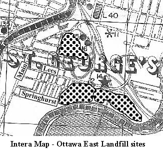
You guessed it! The solution was to truck the noxious material to a big hole in Ottawa East. There was plenty of vacant land, good roads and liquid that oozed out of the dump would simply be washed away by the river. Out of sight - out of mind - excellent solution! Once again the community was given the privilege of contributing to the vision of a "Greater Ottawa". The 1988 Intera Report that assessed former industrial sites shows three garbage dumps (later referred to as landfill sites) in the Ottawa East community. Greenfield Ave., Concord Street North and the railway tracks bound the northern site (L36). This area was originally a low marshy area with a major creek that drained into the river (an ideal location for a garbage dump!). This area must have been used after 1907 because there is no mention of it in the village minutes. No date has been found regarding the closure of this site. The specific location is listed as Lot 6, Concession D. From the map it appears to be the later location of the Morrison-Lamothe Bakery vehicle yard. Two other garbage dumps (L12 and L28) were located south of Lees Ave.
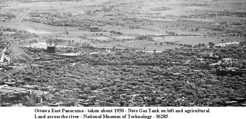
between Chestnut Street and By the end of the 1940's Ottawa East had run out of space for city garbage. The city in all its wisdom solved the problem by simply moving the dump across the river. As the panoramic picture here shows, the land at that time was almost entirely agricultural. The map shows that the city created a massive site from near Hurdman Bridge to Billings Bridge between the river and Riverside Drive. The good news is that the area is now rolling parkland with a bicycle path that will never be built upon. Look closely the next time you travel by the area and you will see pipes sticking out of the larger hills. These are vents for the gases still being produced in the rotting garbage just below the surface. The visible evidence of the industrialization of Ottawa East begun in
1907 has all but disappeared now. High-rise apartments, a college campus
and a bus station have replaced gas and tar works. New forest and meadow
now cover the remaining land. But a lasting legacy still lurks just beneath
the surface and it will be centuries before this material completely dissipates.
So much for Ellis' vision of a "Greater Ottawa". |
| Footnotes: 1 - Intera Technologies Ltd, Mapping and Assessment of Former Industrial Sites, prepared for the City of Ottawa, July 1988, City Reference M7545. 2 - In researching this topic every available source was consulted included the Enbridge Company (the modern version of Ottawa and Consumer's Gas). Very little information was forthcoming. It was almost as if they wanted to forget about this period in their history! |
 the railway lines at the river. From the scant information found to date
and as evidenced by the air photos, these dumps were used in the 1930's
and 40's. Again strategically located beside the river, this rotting material
was annually soaked by the spring floods that washed tons of contaminants
into the waterway. It is often said that this area has not been developed,
as much of the property is still owned by the federal government. Not
so! Landfill sites do not support heavy buildings and dangerous gases
such as methane can seep into subsurface structures. That's why only small,
one-story houses without basements were built in the Chestnut - Brunswick
Avenue area.
the railway lines at the river. From the scant information found to date
and as evidenced by the air photos, these dumps were used in the 1930's
and 40's. Again strategically located beside the river, this rotting material
was annually soaked by the spring floods that washed tons of contaminants
into the waterway. It is often said that this area has not been developed,
as much of the property is still owned by the federal government. Not
so! Landfill sites do not support heavy buildings and dangerous gases
such as methane can seep into subsurface structures. That's why only small,
one-story houses without basements were built in the Chestnut - Brunswick
Avenue area.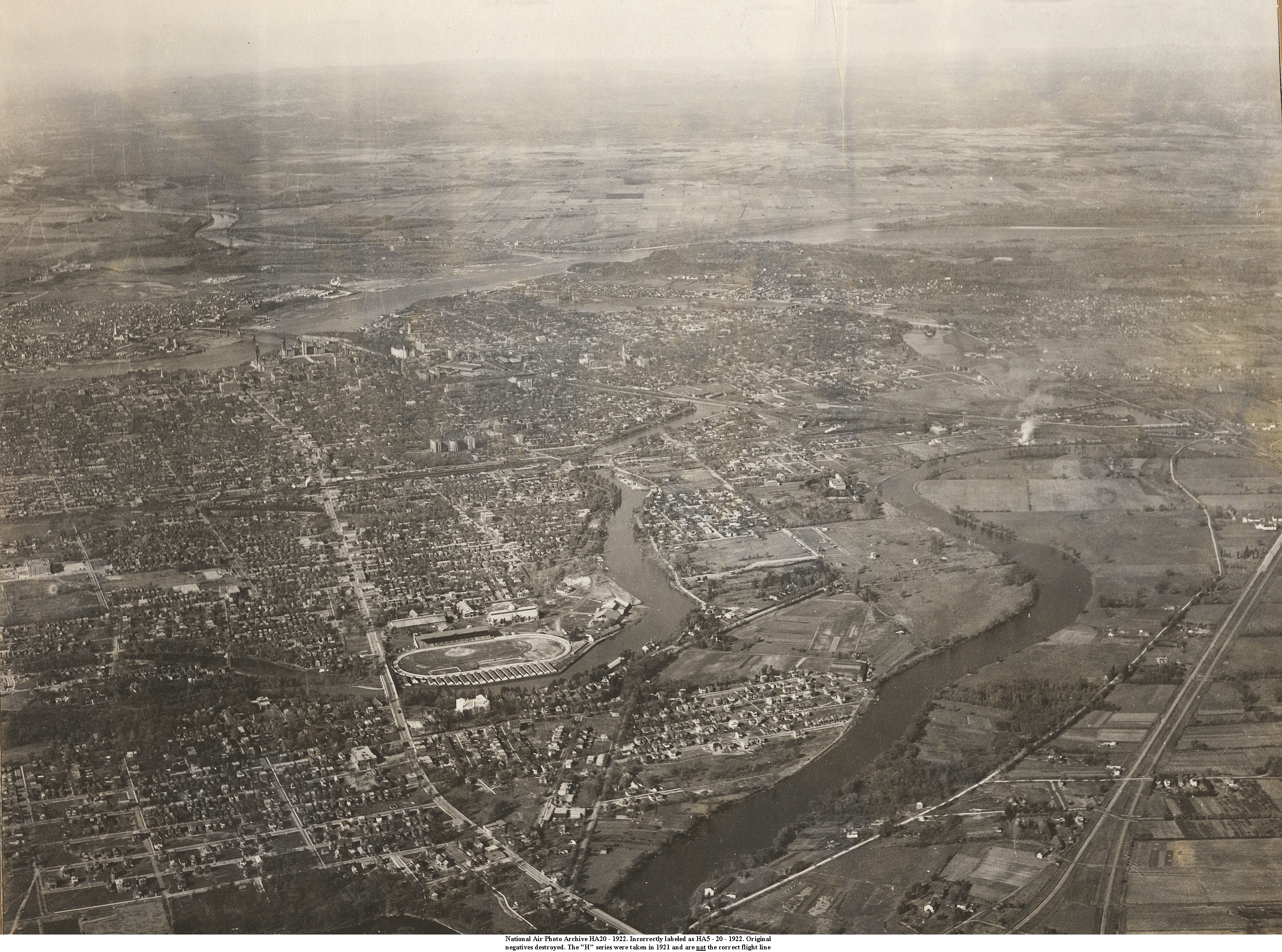