
| Project Information |
| History |
| Mainstreeter |
| Churches |
| Scholasticate |
| Schools |
| Railways |
| Notables |
| After 1907 |
| 1901 Snapshot |
| Air Photo Study |
| Image Library |
| Databases |
| Search |
|
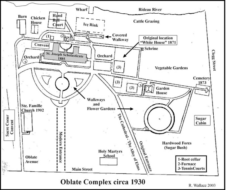
Composite Sketch Map of the Scholasticate
Grounds in the 1930's
|
| The sketch map shown below is a tracing of an original prepared by the Oblates for an anniversary presentation a few years ago. Certain elements have been added to reflect more of the activities at the St. Joseph Scholasticate that took place during the 1930's. Various map locations have been linked to annotated pictures found in the Image Gallery elsewhere on the CD-ROM. |
| Here an imaginary walk through these grounds is described in another section. The viewer may wish to toggle back and forth between this page and the map to gain a better orientation of the location. |
| Move the cursor over the map and when a hot spot is located, a cue card fly-out will appear identifying the picture. Click in the same location and a full size picture will appear. |

| Bonus: For the viewer who perseveres, a Secret Spot may be located somewhere on the map. Going to this picture will provide the viewer with a bonus for the effort. |