| Project Information |
| History |
| Mainstreeter |
| Churches |
| Scholasticate |
| Schools |
| Railways |
| Notables |
| After 1907 |
| 1901 Snapshot |
| Air Photo Study |
| Image Library |
| Databases |
| Search |
|
Chapter One:
the Historical Setting
|
|
Early
Settlement
|
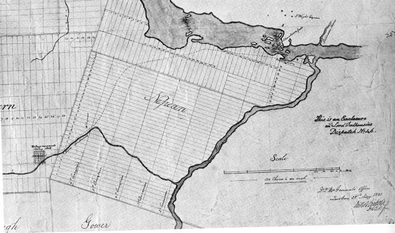
| The evolution of Ottawa East can be understood by examining the historical roots of this "neighbourhood". And these roots go back as far as the beginning of Canada itself. The actions of a distant British government influenced everything from the settlement patterns and transportation routes and even the selection of the people who settled here. |
The beginning of organized
settlement was around 1791 with the establishment of Upper Canada and a
survey of the land. On October 6, 1792, the Township of Nepean was granted
(1). The area was named after Sir Evan Nepean
(1751 – 1822), an Under-Secretary at the Home Office in  London,
and the administrator for Canadian affairs from 1782 to 1794 (2).
He never actually visited Canada but that was typical of most English colonial
officials at the time. Official policy in the 1790’s was to encourage
settlement in both Upper and Lower (Quebec) Canada. This was particularly
important given the loss of the American Colonies to the south and the massive
influx of British Empire Loyalists fleeing from their rebellious neighbours.
The idea was to create a permanent white population to prevent further American
expansion and to consolidate the British hold. By granting free land in
townships such as Nepean, the British government hoped to speed the process
of settlement. The order of the day was to settle the land by granting the
responsibility to groups of "leaders and associates" led by an
individual who would be given a large personal tract of land for his efforts. London,
and the administrator for Canadian affairs from 1782 to 1794 (2).
He never actually visited Canada but that was typical of most English colonial
officials at the time. Official policy in the 1790’s was to encourage
settlement in both Upper and Lower (Quebec) Canada. This was particularly
important given the loss of the American Colonies to the south and the massive
influx of British Empire Loyalists fleeing from their rebellious neighbours.
The idea was to create a permanent white population to prevent further American
expansion and to consolidate the British hold. By granting free land in
townships such as Nepean, the British government hoped to speed the process
of settlement. The order of the day was to settle the land by granting the
responsibility to groups of "leaders and associates" led by an
individual who would be given a large personal tract of land for his efforts.
|
|
The first person to be granted
land in this way was an Irish veteran of the Revolutionary War, one George By 1800 there was an increased
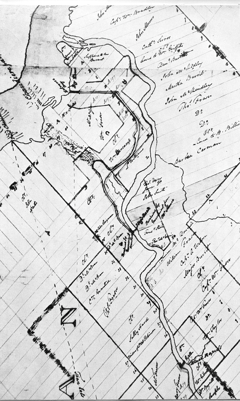
demand for land in Nepean from the Few Loyalists or their heirs ever settled in Nepean; they preferred the rich farmlands along the St. Lawrence River and Lake Ontario. The land they held passed from one person to the next for as little as a pound (5). While the population of Nepean Township slowly increased in the first decades of the Nineteenth Century, the number of land speculators abounded with hopes for future profit. Much of the land in the northeast
part of the township was purchased by the Loyalist Fraser family, who
Another major landholder in
the northeast of Nepean was Lewis Williams, of Monmouthshire, England.
A farmer, he landed in Quebec in 1817 and eventually located on the Rideau
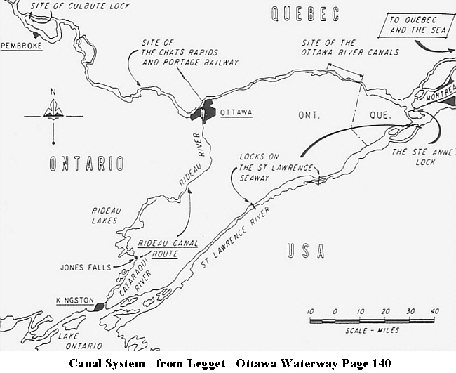
Front (Rideau River) that By the early 1820’s, the British government had become distrustful of Upper Canadians with American origin and set about to encourage the settlement of a loyal population. In 1815 the Colonial Office decided to disband units of the regular army in the colony and, coupled with unemployed Scottish weavers, to settle some of these people on the grantable land of the Crown Reserves in Nepean. But by 1824 only 4 families had been settled in the township including Lewis Williams mentioned above. By the mid-1820’s then, the situation in Nepean was arguably not much different than the late 1780’s. "In 1822, Nepean’s population was only 191" (9), consisting of 35 families scattered about the township. There were 2 half-pay officers, 5 soldiers, 9 Americans, 7 Irish Protestant immigrants, 5 Scots, 5 Englishmen, a single Irish Catholic and one of unknown origin (10). The few permanent settlers in the northeast of Nepean gravitated more to the Hull Township, established by Philemon Wright in 1800, across the Ottawa River. The establishment of a military depot in 1818 at Richmond had begun to attract more British settlers to Nepean but in general settlement was sparse. The system of granting free land had not worked. In fact the speculation that the system had fostered had hindered rather than encouraged settlement. The situation was perhaps best summed up by the Earl of Dalhousie, governor-in-chief, who wrote in 1820 that: "From Richmond landing place to the village of Richmond, 22 miles, it is almost wholly waste & wild woods, the property of absentees or Crown & Clergy Reserves, but generally in large grants made by the Government of Upper Canada which then can neither recall, nor force into settlement. This Township of Nepean . . . therefore may be considered as useless waste, a serious difficulty in the way of prosperity of this part of the Country, and it is mortifying in a greater degree from its possessing the only harbour & approach – by which the great object of these settlements can be attained." (11) This began to radically change in 1826! By and the Rideau Canal Lands Still recovering from the loss of the American Colonies and the War of 1812 – 14, as well as the slow increase in settlement, the government began to make a policy changes in 1826. Free land was now no longer available (except for Loyalists and retired soldiers). Settlers now had to purchase land from the Crown or individual owners such as the Loyalists who held about half of the township land. The Crown Reserves that remained unsettled were sold to the Canada Land Company, a group of speculators based in England. The Clergy Reserves, originally intended for the Church of England (Anglicans), were also authorized for sale. The effect of this policy change was a stimulation of settlement. Also in 1826, a project was initiated that would significantly alter the geography of Nepean forever. This was the building of the Rideau Canal. Wary of possible future attack by Americans on the vital shipping route from Montreal to York (Toronto), the British government decided to create an inland route that would bypass the section of the St. Lawrence River from Montreal to Kingston. This required that the Rideau River be made navigable from Kingston to Ottawa as shown by the map here. For more detail on all of the locks required to make the Montreal to Ottawa to Kingston sections navigable, go here.
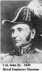
This massive undertaking was made the responsibility of Lt.-Col. John By of the Royal Engineers. His genius and work continues to influence the face of Ottawa to this day! The immediate effect of the
canal project was to dramatically increase the population, particularly
in the From the very outset of canal construction, land speculation and ownership created problems. Lord Dalhousie, now the Governor General had purchase 415 acres of land from Hugh Fraser (see map of holdings) for a town site near the junction of the Ottawa and Rideau Rivers (Bytown). In late 1826, Col. By hired John MacTaggart to investigate possible routes for the waterway from Abram Dow’s Great Swamp to the Ottawa River (14). The best route was found to be from the northeast corner of present-day Dow’s Lake, down a natural gully (Preston St.), to the Ottawa River just west of the Chaudière Falls. This land was owned by Captain John Lebreton, purchased in 1820 (now Lebreton Flats). This ownership resulted in one of the more interesting stories of early Ottawa. Lebreton had paid £499 for the land and offered it back to the government for £3000 (15). Upon hearing this, the Dalhousie became furious, accused the Captain of breach of trust by using inside information on the canal to speculate; and then ordered Col. By to alter the route of the canal to the course it follows today. There is much more to this
story but it is sufficient here to note that had Lebreton not purchased
the land, Land speculation not only influenced the canal route but it also had a negative effect on the work force. By saw a need for farmland near the canal to settle over 200 families of workers. However, much of the land was owned by the Canada Land Company and was too expensive for the average worker. By then ordered a survey of Ordnance Land (controlled by the military) and apportioned small lots along the canal for workers to rent for a shilling an acre (16). In doing so, it was hoped "to establish . . . along the route a permanent improving chain of settlers whose interests might be identified with the Canal, The waters of which would offer a ready transport as well for their produce to Market, as for the supply of imported Articles necessary for their consumption" (17).
In essence, By’s foresight became the precursor for later settlement and use of the canal by residents of Ottawa East.
With rental revenues being
lost, disputes over property lines and unauthorized settlement by squatters,
the board of Ordnance requested a perambulation report (inspection on
foot) of the entire 126 miles of the canal. Apart from opening a rent
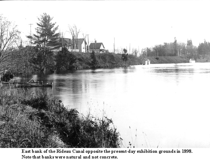
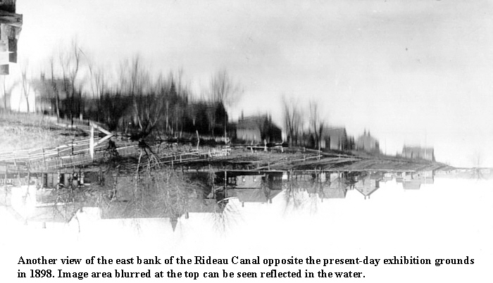
ledger, very little else was The relevance of this land saga to our story is that from the early 1830’s to nearly the end of that century, settlement along the Ottawa East section of the canal land consisted of a hodgepodge of development. It was not until the 1860’s that this situation began to be attenuated when the registered plans of subdivision brought a semblance of legal order. In 1873, the Dominion Government reduced the canal reserve land to a 200-foot strip on either side of the waterway (later to become the Driveways); surveyed and sold the remaining land; and ejected all the squatters. Footnotes: For complete references, see Sources
|


 northeast.
In 1828, there were 2,758 people listed in the township
(12) with a largely transient group of workers centered
in ByVille (1826), later Bytown (13). Canal
workers were mostly Irish immigrants with some Scots, Englishmen and a
few French-Canadians. The majority were family men who were to become
permanent residents of the area after completion of the canal. In addition,
many Nepean farmers sought work on the canal, which resulted in a cash
infusion to the rural part of the township.
northeast.
In 1828, there were 2,758 people listed in the township
(12) with a largely transient group of workers centered
in ByVille (1826), later Bytown (13). Canal
workers were mostly Irish immigrants with some Scots, Englishmen and a
few French-Canadians. The majority were family men who were to become
permanent residents of the area after completion of the canal. In addition,
many Nepean farmers sought work on the canal, which resulted in a cash
infusion to the rural part of the township.