
| Project Information |
| History |
| Mainstreeter |
| Churches |
| Scholasticate |
| Schools |
| Railways |
| Notables |
| After 1907 |
| 1901 Snapshot |
| Air Photo Study |
| Image Library |
| Databases |
| Search |
|
Chapter Two:
Early Rideau Front Settlement
|
|
Ottawa East
Begins To Emerge
|
The northeast part of Nepean was the last to be occupied in the 1840’s.
The area between the canal and the Rideau River was part of the Merivale
District of Nepean and was known as the "back bush" (1).
Much of the land on both sides of the river was held by absentee speculators
such as the Fraser family and was largely unavailable to individual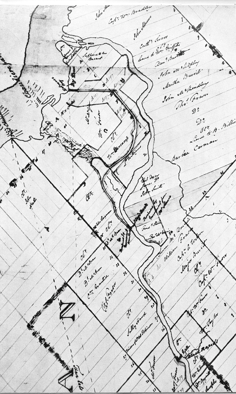 settlers due to the cost. Those settlers that did come were mostly Irish
Presbyterians from the northeast of Ireland. They were certainly not wealthy
and were attracted to this area where available land was cheaper than in
other parts of the township. In the late 1840’s more land became available
as financial pressures forced most of the original speculators to sell.
This resulted in an opening up of the Ottawa East area for agricultural
and later, residential development.
settlers due to the cost. Those settlers that did come were mostly Irish
Presbyterians from the northeast of Ireland. They were certainly not wealthy
and were attracted to this area where available land was cheaper than in
other parts of the township. In the late 1840’s more land became available
as financial pressures forced most of the original speculators to sell.
This resulted in an opening up of the Ottawa East area for agricultural
and later, residential development. |
| At the beginning of the 1850’s, the small urban community of Bytown continued to grow as the market focus for the surrounding area north and south of the Ottawa River. As well the community was an important entrepôt (intermediary center of trade and transshipment) for the timer industry of the Ottawa Valley connecting to Montreal and markets in Europe and the United States. In 1850 the community separated from Nepean Township and in 1855 became the City of Ottawa. |
|
It is important at this point in the story to note that the City of Ottawa proper stopped at the southern boundary of Gladstone/Mann Avenues (See Map). Everything south of that east to west line was technically a suburb. While the City continued to evolve from a commercial/sawmilling function to a civil service center, the surrounding areas developed as separate and distinct communities initially created by land speculators. The economic success of these communities was largely dependent on access to the City, via available transportation, for the sale of goods, produce and employment. While distinct politically, the prosperity of the suburbs (including the Ottawa East area) was dependent on the larger city. As with other communities such as Rochesterville, Hintonburg, Mount Sherwood, the area that was to become Ottawa East Village began to develop its own unique character. To describe the aerial extent of our story, it is best to follow the structure presented by the original land survey that sectioned the region into Concessions and Lots. Of particular interest are the Concessions of C and D and Lots F to L. Using present-day roads, Concession C is bounded by Bronson Avenue in the west and Main St. in the east. Concession D is bounded in the west by Main St. and in the east by the Rideau River.
The northern boundary of Lot F is the east/west line of Gladstone and Mann Avenues. All the remaining lots (G to L) are lettered south from here. Lot "F" – Bordered by Bronson Ave., Gladstone/Mann Avenues, Rideau River and Isabella Street.
In 1834 he purchased 200 acres from a Loyalist speculator who had received the land as a grant from the Crown and had left it undeveloped. Identified as Lot F, Concession C, this land is now surrounded by Bronson Ave., Isabella St., Gladstone Ave., and the Rideau Canal. Later, in 1844, according to land records, he was granted an additional 104 acres of the Lot F in Conc. D. This adjoined his holdings to the east across the canal. In 1852, when Bytown residents began to lobby the Legislature for city status, Stewart appealed to the local council for exclusion of his property. He pleaded that: "the present limit of the town is large enough for the next half century . . . there are upwards of a thousand acres of land now within the town without being occupied by one building . . . nearly two hundred acres of (my) land (is) under original forest [and] . . . it would be unjust and exceedingly oppressive to assess such unproductive property at City of Town valuation" (2). As a result of his influential lobbying, in 1855 when Ottawa officially became a city, the southern line was fixed at the northern boundary of his land (Ann Street, later to become Gladstone and Mann Avenues). William Stewart's prediction of a lapse of 50 years before the land would
be needed was not to prove Lot "G" – bordered by the Queensway (approximately) and Springhurst Avenue. South of the Stewart holdings was Lot G in both Concessions C and D.
The dividing line between these two concessions was a road allowance that
was later to become Main Street. Lot G, Conc. C was Up until the building of the Rideau Canal, the only road available for north-south transportation was a ‘forced’ road (following the shape of the land, not survey lines). This ran from the Ottawa River at the Chaudière Falls, south around the northern extent of Dow’s Great Swamp (later Dow’s lake) to the Rideau River opposite Braddish Billings’ farm across the river in Gloucester Township. As the canal cut this road in 1830 a new bridge was needed. It was decided however to utilize the cleared land along the canal for a more useful road. A new road was then cut from what is today Billings Bridge, along the future course of Riverdale Avenue to the eastern bank of the canal at approximately Bristol Ave. and then on to Lower Town. This rerouting of traffic was to prove highly advantageous for the later development of Ottawa East as this road remained the main route between Gloucester and the city will into the 1860’s. After Ottawa became a city in 1855, the land east of the canal in Lot
G became of interest particularly to
In the early 1860’s, the Ottawa East land south of the city was fundamentally a rural neighbourhood populated by farmers and labouring families. Lees, in a desire to escape urban life, had built his home in a forest and aptly named it Wildwood. Apart from agrarian practices, there was very little in the way of commercial activity. One exception was a crude tavern, run by a black American Henry Westbrook, located on the eastern bank of the canal at present-day Clegg St. (3). Lot "H" – Northern boundary in Conc. C is
Glebe Ave. and the southern boundary is Fifth Ave. In Conc. D, the northern
boundary is approximately where Oblate St. intersects with Main St. and
along the southern limit of the Immaculate High School land. The southern
line of this lot is Clegg St. John Fitzsimmons originally owned this lot in Conc. D. In 1863 the majority of the land was sold to the Roman Catholic College of St. Joseph. Later this land was to become St. Joseph’s Scholasticate of the Oblate Order and St. Paul’s University. Fitzsimmons retained the northwestern corner of the lot for later development as residential property. This may explain the curious little string of homes between Springhurst and Oblate Streets nearly surrounded by a massive Catholic complex. Across the street from the Catholic holdings in Lot H, Conc. C, the land was owned by another powerful religious denomination – the Presbyterians!
"April 3 1837 during the Reign of King William IV, there was issued a Crown Grant . . . covering all that portion of Lot ""H" Concession "C" Township of Nepean . . . containing 178 acres . . . to hold hereafter as a Glebe" (4). Therein lies the derivation of the name of one of Ottawa’s most desirable neighbourhoods.
Lot I – Northern boundary is Clegg St. and the southern boundary is approximately an east to west line along the back of the lots on Elliott St. This line is projected from the canal to the Rideau River. Moving still further south, the land was decidedly rural with the vast majority of the area owned by a few farmers and the Mutchmor Family. In Conc. D, (to the east of Main St.) all of the land was owned by John Fitzsimmons. Very little has been found regarding this family. This lot in Conc. C extended from the road allowance (Main St.) in the east to Bronson Ave. in the west. Originally owned by the Fraser Family, the land was acquired by the John Mutchmor Family in 1836 (7) from William Vancamp. This family and relatives were to play a major role in the development of land along Bank St. and later in Ottawa South with the establishment of Rideauville. Originally the Mutchmors had little success at farming this land and left the Ottawa region for the United States in 1839 (8). But when Ottawa was announced as the new capital, the family saw the value of their land increase and returned in 1861 (9). In 1864 they divided their holdings on both sides of the canal into blocks which were used initially by "gardeners and nurserymen (10). Early maps show that some of this land was owned by Bates but again, no information on this person has been found to date. Lots K and L – Technically the description of the area that was to become Ottawa East Village should end here. The legal southern boundary of the village is the line between Lots I and K. Specifically this line would be found at the back of the properties on the north side of Elliot St. Therefore any land south of this line may be more properly classified as Ottawa South. But historical geography rarely matches lot lines. Therefore the story will continue south, down Main St. to the Smyth Road Bridge at the Rideau River. Should anyone take personal umbrage with the decision, this writer is prepared to meet that person, ‘con las pistolas’, at dawn on any day, at the original site of the Ottawa East Village Water Department Pumping Station. As well, the small sliver of land along the canal opposite Lansdowne Park will be included. The reader will discover that the geographic proximity of these two areas to the later Ottawa East Village requires that they be examined in the context of our story, notwithstanding the survey lines. Lot K, Conc. D was owned originally by William Powell who acquired the
land from the Crown in 1869 (Land Records – Conc. D – Vol.#7).
William Slattery, a wealthy farmer and butcher purchased the land in 1872;
and maintained extensive pasture land in the area. Not only was he one
of the first importers of western beef but he was also instrumental in
advancing animal husbandry in Nepean Township. To the west of the concession dividing line (Main St.) were the extensive holdings of Lewis Williams (mentioned earlier). One of the original settlers, he came to the area in 1817 with his wife, 4 sons and 2 daughters (12). His original house at 96 Southern Drive still stands. In 1874 the farm was divided with 54 acres sold in the western part. This later became Rideauville. He also attempted to speculate in the late 1870's laying out a "subdivision of his own at the Fairburn farm just north of Billings Bridge (13), but it was unsuccessful. There is more on the Williams family in the Notables section located here. Lot L presents some difficulty in delineating which parts were more connected with Ottawa East than with Ottawa South. An 1828 map (14) drawn for Col. By shows the entire lot being owned by Lewis Williams from what is now Bronson Ave. to the Rideau River. Essentially it represents only a tiny piece of land where the west end of Rideau Gardens Drive is today. From Lots F to L, in Concessions C and D, the stage was set for the next period of Ottawa East’s evolution. All the constituent parts were in place for the coalescence of a new community as Ottawa became the Nation’s capital. The expected land boom of the late 1860’s and 1870’s throughout the region was to have a marked effect on the Village. Footnotes: For complete references, see SOURCES here.
|

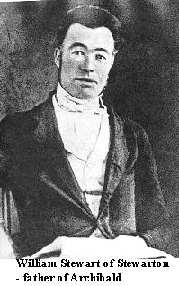 Circa
1850, the land immediately south of the future City of Ottawa was that
owned by William Stewart – the grandfather of Ottawa East. Stewart
wore many hats during his time in the area. Originally from Scotland,
he was a merchant when he first arrived in Bytown. He quickly became one
of the most influential men in the community through his duties as a land
agent, lumberman, landlord, president of the county agricultural society,
Assemblyman and leading member of St. Andrew’s Presbyterian Church.
There is much more on the Stewart Family and Stewarton located
Circa
1850, the land immediately south of the future City of Ottawa was that
owned by William Stewart – the grandfather of Ottawa East. Stewart
wore many hats during his time in the area. Originally from Scotland,
he was a merchant when he first arrived in Bytown. He quickly became one
of the most influential men in the community through his duties as a land
agent, lumberman, landlord, president of the county agricultural society,
Assemblyman and leading member of St. Andrew’s Presbyterian Church.
There is much more on the Stewart Family and Stewarton located 


