| Project Information |
| History |
| Mainstreeter |
| Churches |
| Scholasticate |
| Schools |
| Railways |
| Notables |
| After 1907 |
| 1901 Snapshot |
| Air Photo Study |
| Image Library |
| Databases |
| Search |
|
Brantwood Place
|
| Annexation of many suburbs in 1907 rekindled an interest in the residential
development of Ottawa East. As part of Mayor Ellis' vision of a "Greater
Ottawa", the agricultural land between Main, Clegg and the Rideau River
was now viewed by developers as having future potential.
In March of 1911, Robert A. Sibbitt and Nepean Realty Ltd. purchased
the majority of the land in Concession D, Lot I (Rideau Front) for $94,000.
Sibbitt's plan was to create a huge residential subdivision and market
the lots as "a residential section for the discriminating and a boulevard
homesite for the particular". He named the neighbourhood "Brantwood
Place". |
 |
|
The success of the concept was based entirely on the idea
that "upscale" homebuyers would be attracted to the lots by
aggressive marketing and the promise of future amenities such as a streetcar
line. That was a tall order given the near isolation of Ottawa East at
the time. While the swing bridge across the canal (just north of present-day
Pretoria Bridge) did provide a connection to the city, it could not support
the electric trolley from Elgin St. As well, questions about adequate
water, sewer and electrical services had to be answered. One can only
speculate how the problem of the annual spring flood was addressed.
To answer these questions and promote Brantwood Place Sibbitt produced
the now-famous brochure (reproduced in part here).
Approximately 10 by 7 inches with 4 colours, the elaborate document
contained numerous graphics, photographs and marketing text that bordered
on hyperbole. In it Sibbitt answered all of the questions with future
promises and characterized the surroundings as being ideal for the discriminating
purchaser. He described the brochure content as "being the story
of an effort to please the fastidious". |
|
 |
|
|
The actual date of publication is not clear. The brochure
has several references to 1911 as well as the proposed "high level"
bridge over the canal at Bank St. There is also a mention of the proposed
bridge from Mutchmor (Fifth Ave.) to Clegg St. - an active topic in 1912.
There is no mention of Pretoria Bridge that was to be approved in 1914.
So with a wee bit of inductive thinking, a good guess for the date of
publication is circa 1912-13. The Plan of Subdivision was filed on December
6, 1913 (M45).
Sibbitt's main answer to the "heretofore impassible barrier of
the canal" was the rebuilding of Bank St. Bridge that would extend
the streetcar services up Riverdale and Main. Until that time, he indicated
that "it is even now but a 12 minutes walk from the end of either
Elgin Street or Bank Street car lines to the property - with granolithic
(cement) walks all the way up Main St.". He neglected to mention
that there was no snow removal for sidewalks, making it somewhat difficult
to trudge up Main in subzero weather. |
|
|
He went on to confirm that all necessary services (water,
sewers, telephone and electricity) were "all available". But
at what cost and when? Many of the lots needed to be sold to finance installation
of the services. To further support his vision ten
specific restrictions on sales were listed to ensure ""good
neighbors - congenial surroundings - and permanent residential value".
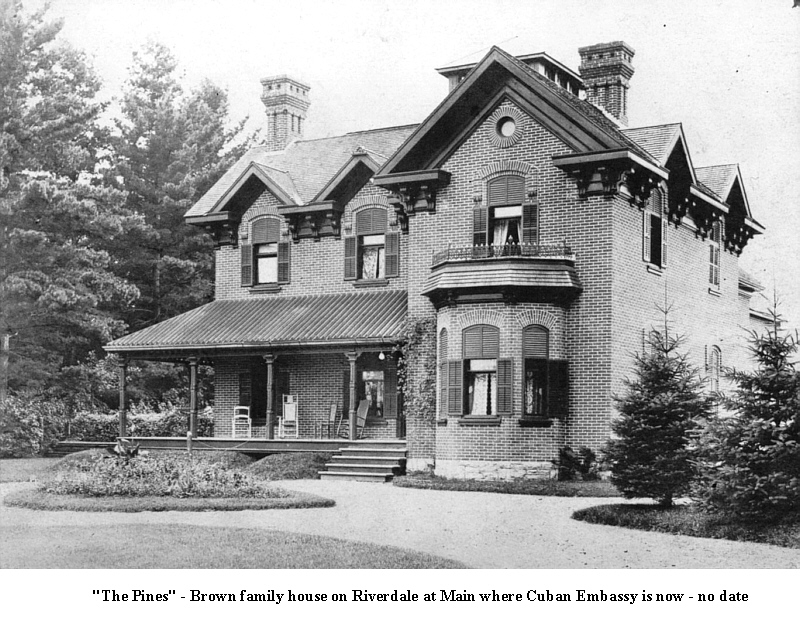
As examples of the "character and quality of the neighbourhood"
he included pictures of the Brown and Slattery residences on Riverdale
Ave. and the entrance to St. Joseph's Scholasticate.
|
|
 |
 |
 |
 |
|
To further buttress the idea of exclusivity Sibbitt built
the landmark "Stone Gates". Now an Ottawa East
 icon, the four stone pillars constructed on Main at Beckwith were made
of local field stone set in a concrete matrix, on top of concrete base,
filled with rubble and capped by "stone balls". The brochure
suggests that an ornamental arch of ironwork was installed connecting
the inside pillars. Local legend has it that the arch was removed early
on as it became a hazard. As time has shown, Sibbitt was not concerned
with durability as the vagaries of weather and traffic have created problems
for the structures. There is much more on this story here.
icon, the four stone pillars constructed on Main at Beckwith were made
of local field stone set in a concrete matrix, on top of concrete base,
filled with rubble and capped by "stone balls". The brochure
suggests that an ornamental arch of ironwork was installed connecting
the inside pillars. Local legend has it that the arch was removed early
on as it became a hazard. As time has shown, Sibbitt was not concerned
with durability as the vagaries of weather and traffic have created problems
for the structures. There is much more on this story here. |
|
|
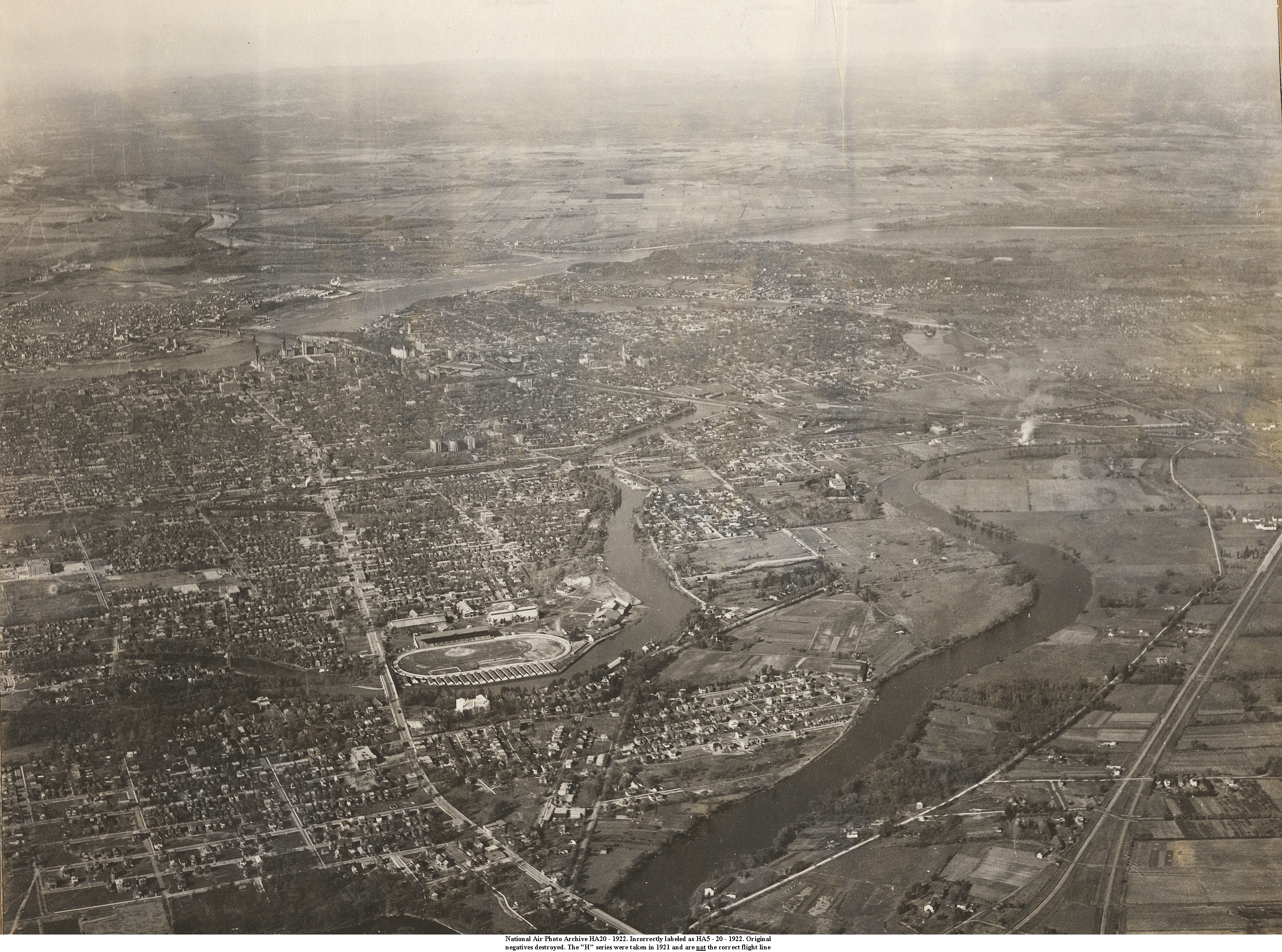
With all of his effort however, the anticipated interest
in Brantwood Place did not materialize. Notwithstanding the building of
Pretoria Bridge and the extension of public transport, sale of the lots
was very slow. The 1922 oblique air photo of Brantwood Place shows the
entrance gates at Beckwith with little else. Only a portion of Beckwith,
Marlowe and Clegg were constructed with just a few houses built. As the
sequence of air photos below demonstrates, Sibbitt's original vision was
not realized for many years. In the end, one of the most desirable neighbourhoods
in the region did emerge. With a beautiful beach that attracted thousands
on a hot summer's day, no commercial development and the later extension
of the community south of Elliot St., the community grew rapidly after
the Second World War. That story has been left to a future time.
|
|
|
1922 |
1928 |
|
1931
|
1938 |
|
1956 |
1960 |