
| Project Information |
| History |
| Mainstreeter |
| Churches |
| Scholasticate |
| Schools |
| Railways |
| Notables |
| After 1907 |
| 1901 Snapshot |
| Air Photo Study |
| Image Library |
| Databases |
| Search |
|
Horace Culver O'Dell
|
| The very first industry established in the Ottawa East area was the O'Dell
brickyard located on what is now Lees Avenue near Simcoe St. The location
was attractive to brickmakers because of the extensive clay and sand deposits
along the Rideau River as well as cheap land. As Ottawa grew so did the
demand for locally produced brick. With proximity to the canal and railways
(in the 1880's), the brickyard flourished.
Horace Culver O'Dell was born in the United States about 1817 and emigrated to Canada in the early 1860's. He first appears in the Nepean Assessment Roll in 1865 as a tenant on land owned by the Stewarts. This roll also lists an Amos O'Dell in 1863 as a non-resident. Perhaps this was brother or father. By the 1880's O'Dell owned a large amount of property surrounding the brickyard that was later sold for development. He died on March 4, 1891 in his home at 158 Nicholas St. The 1881 Census lists the family as follows: |
| Name | Marital Status | Gender | Age | Birthplace | Occupation |
| Horace C. O DELL Caroline O DELL Clarence H. O DELL Edith O DELL Walter O DELL Lily O DELL Mortimer O DELL Theresa LANGFORD Homer LANGFORD Mildred LANGFORD |
M M W* |
Male Female Male Female Male Female Male Female Male Female |
62 54 26 28 24 20 15 30 4 2 |
USA Ontario Ontario Ontario Ontario Ontario Ontario Ontario Ontario Ontario |
Brick Manf.
Clerk Clerk |
| * Widow - She was the daughter of Horace as listed in the 1871 Census | |||||
| There is more on Horace found here. This information was extracted from the 1871 Census schedules and describes his brick business at the time. | |
|
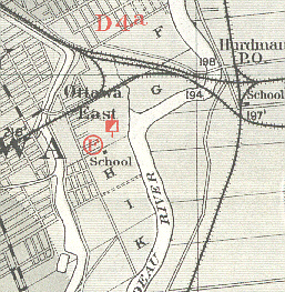
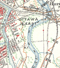
The O'Dell brickyard continued to function after the death of Horace and was under the direction of his sons Clarence (died 1907), Walter and Mortimer O'Dell when it closed. The 1901 Geological Map of Ottawa, published by R. W. Ells and supporting documentation by H. M. Ami identifies the location of the brickyard and mentions these two sons. The 1918 map produced by the Department of Militia and Defence from a 1906 survey (Sheet #14 at University of Ottawa) shows the brickyard on Lees as well as the Graham Brickyard (later Cain's ?) at the end of Clegg St. besided the Rideau River. |
|
 |
 |
|
The map above shows the location of the O'Dell Brickyard in 1901 (red/white flag) towards the end of Lees Ave. The circled "F" on Springhurst Ave. represents a fossil location. The "School" is the Scholasticate. Note the major stream that runs south from the railway tracks to empty into the Rideau River. |
The map directly above was produced by the Department of Militial and Defence in 1918 based on a 1906 survey. Look carefully just to the left of the "E" in East and you will see the symbol "B.Y." representing "brickyard". Directly south you will also see the symbol representing the Graham (Cain) brickyard. Note that the stream is now gone. |