
| Project Information |
| History |
| Mainstreeter |
| Churches |
| Scholasticate |
| Schools |
| Railways |
| Notables |
| After 1907 |
| 1901 Snapshot |
| Air Photo Study |
| Image Library |
| Databases |
| Search |
|
Chapter
Three: The 1860's and 1870's
|
| As the 1860’s dawned Ottawa East was still sparsely populated as compared to the City of Ottawa proper. The most sought after residential locations were close to where people worked and did business since the main mode of transport was walking. Streets of heavy wooden planks were preferable to the mud and dust of the suburbs. Additionally, "the suburbs clustered the disadvantaged, the undesirable, and the practitioners of noxious trades, such as tanning and slaughtering" (1). That was Ottawa East. |
Most of the Ottawa East area that was not covered by the dense wide "bush"
along the east bank of the Rideau River was under cultivation. Large farms
and leased market gardens 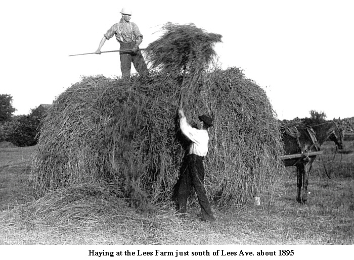 dominated
the community and connected to the northern industrial/residential area
by the Canal Road and the Concession Road between Conc. C and D, later to
be called Main St.(2). Here residences were
interspersed with brickyards and slaughterhouses in close proximity to the
rail lines and the Canal. There were a few exceptions such as Wildwood,
Robert Lees' residence situated amongst the hayfields and orchards of what
is now Lees Avenue. dominated
the community and connected to the northern industrial/residential area
by the Canal Road and the Concession Road between Conc. C and D, later to
be called Main St.(2). Here residences were
interspersed with brickyards and slaughterhouses in close proximity to the
rail lines and the Canal. There were a few exceptions such as Wildwood,
Robert Lees' residence situated amongst the hayfields and orchards of what
is now Lees Avenue. |
|
There had been little development in the Ottawa East area after Ottawa achieved city status in 1855. There was interest on the part of some lawyers as the land was relatively inexpensive and had ready access via the Canal Road to the courthouse in Lower Town. William Ring and Charles O’Connor bought the land in Conc. C, Lot G east of the Canal from John Hickey in 1859 and created a small subdivision. However, with no buyer interest, Martin O’Gara subsequently purchased the northern section in 1866; and the southern half was sold to John Graham in 1868. The two largest landowners in Conc. D, Lot G were Robert Lees and Thomas Kealey. In 1863, the Oblate Order (Oblates of Mary Immaculate) purchased most of Conc. D, Lot H for St. Joseph’s Scholasticate Henry F. Westbrook, a black American "ran a crude tavern east of the canal on the road allowance" (near Clegg and Echo Drive). " He sold the property to Isaac Biggars in 1865, a deal which apparently included his wife as well" (3). John Graham used his acreage as a market garden to supply his two hotels
in Lower Town, the Albion It is difficult to arrive at a definitive list of all the residents in
in Ottawa East in the 1860's as many were By the end of the 1860’s, the increasing prosperity that came with growing housing needs from a burgeoning civil service and an expanding sawn lumber trade initiated a land boom. The Ottawa Citizen newspaper noted on the 23rd of November, 1871 that "building operations were never more lively than at present . . . (with) communities rapidly rising in numbers and importance in the immediate suburbs . . . only divided from the city by imaginary lines" (4). A record number of registered plans of subdivision were drawn including Archville West. Archville West William Stewart’s holdings, which included most of Lot F in Conc.
C and D, passed to his wife Village of Spenceville
The Spenceville Plan showed the layout of the following streets: Gordon (Hazel), Herridge, Clegg, Rideau (Canal Road, now Echo Drive), McGillivray, Drummond, Bronson (Glenora) and Concession Road Allowance (Main). By the mid-1870’s, the speculative fever that gripped all of the Ottawa area disappeared. The economic depression that began in the United States had quickly spread throughout North America. Vacancy rates soared and with an oversupply of registered lots, no additional subdivisions appeared in Ottawa East. This was a period of hard times for the average working person. "Soup kitchens and bread lines functioned in various parts of the city funded by voluntary subscriptions" (6). Archville by the end of the decade consisted of a few impressive homes and about "56 working families living back of the Ballantyne family’s canal-side coal yard" (7). With a desire to keep taxes down, there were few demands on the Nepean Township Council for improvements in the small community. It must be remembered that although Ottawa East was just next door to the City, whatever support and services it received came from a decidedly rural council dominated by farmers who expected the community to be annexed at any moment. There were no social services or planning. Nepean administration consisted of a clerk and a treasurer located in Bells Corners. The council met regularly but, apart from paying bills for such items as burying dead animals left in the road, there was virtually no initiation of programs or projects. They simply responded with a yes or a no to ratepayers’ requests that were within the very limited legislative authority of a township. The near total lack of improvements in the community was not because of poor planning – there was no planning! And there were no health, police or road departments either. The township had the authority to buy groceries for families afflicted with smallpox but it could not prescribe regulations to limit the spread of the deadly disease. Council could pay to have a dead dog removed from a public well but had no peace officer to lay a charge for the offensive act. All roadwork in the township was done by "statute labour". This system required residents to spend a specified amount of time working on roads as determined by a local overseer. A person had the option of not working and paying a larger tax bill or providing a surrogate in his place.
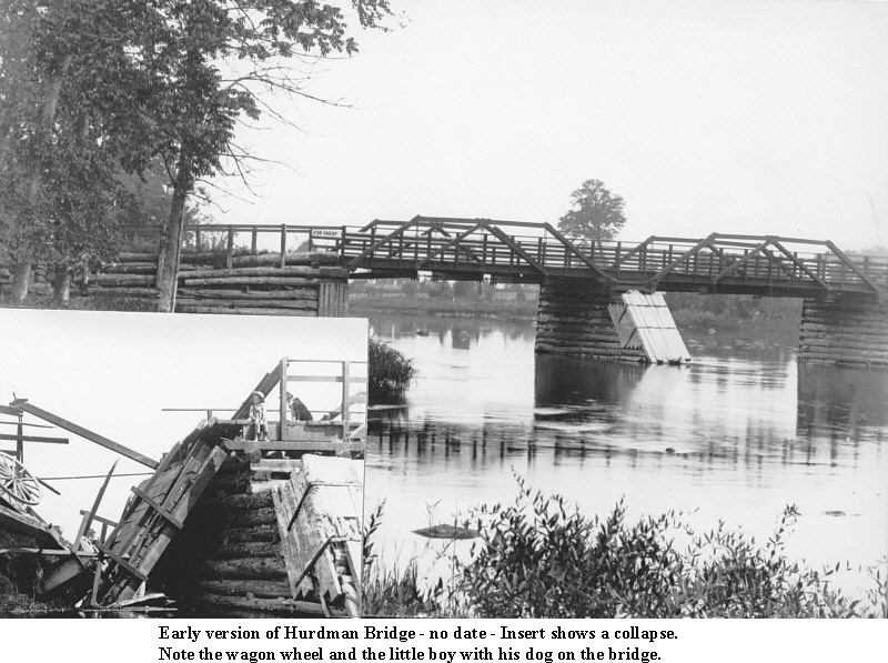
Statute labour and other ratepayer initiated improvements were more often than not subsidized in part by township funds. Such was the case with the building of the Hurdman’s Bridge. In 1872 there were few bridges across the Rideau River (8).
Billings Bridge (originally called the The People – 1871 to 1881 At this point in the story it is important to look at a cross-section of the people and activities in the Ottawa East area to better understand the community that was now rapidly emerging. What had begun in the 1820’s and 30’s as a rural community of a few farms had now evolved into a burgeoning industrial and residential locale in the northern part with scattered farms and market gardens in the center and southern parts. Who were these people? Where did they come from? What did they do? The answers to these and many more questions are, in part, included in this next section. While it is impossible to provide a definitive list of every resident, analysis of records of known inhabitants can give a glimpse of the people who formed the early Ottawa East community. To do this a variety of records has been consulted including the 1871 census manuscript, the 1881 census manuscript and CD-ROM version, the existing directories from 1868 to 1881 and various and sundry history books. No one source contains all the answers. What follows is an amalgamation of these sources, along with some inductive thinking, that illuminates the lives of the people of Ottawa East in the period 1871 to 1881. For an in-depth look at the German Community of Ottawa East go here. Agriculturists – Farmers or Gardeners? The various sources consulted list Ottawa East residents involved in the tilling of the soil as either farmers or gardeners. What is the difference? While there is no definitive description is available at this point, it appears that the size of the acreage, type of crop and proximity to residential areas determines the classification. Those who live close or in the small residential areas such as Archville were usually listed as gardeners – perhaps this was the precursor to the modern term of "market gardener". Agriculturists in the southern part held larger acreage and their crops were mainly used to support livestock. This generalization however, does not hold in all situations as can be seen in the following cross-section of examples. Daniel (Donald?) McGregor purchased a lease for the south half part of blocks No. 9, 10 and 11 in Conc. C, Lot H from the Temporal Committee of St. Andrew’s Presbyterian Church on April 1, 1871 (Land Records). According to the 1871 Census (Schedule #4) he was a gardener of 14 improved acres with 8 acres in pasture and 6 in gardens/orchards. He grew 200 bushels (bu.) of potatoes on 1 acre and listed his only other crops as 30 bu. of turnips and 100 bu. of carrots/other root crops. The Nominal Schedule (#1) of the 1871 Census lists him as married (although his wife was not present at the time of enumeration), 48 years of age and living with his son Duncan aged 12. Both were born in Scotland. Schedule #3 indicates that he owned 12 of the acres leased which is somewhat confusing. He had no livestock and did not harvest any cordwood. John Hickey was a member of a family that owned large tracts of land in the Ottawa East area, both east and west of the Canal. The 1871 Census (lists him as a gardener owning 14 improved acres with 8 in pasture and 6 in gardens/orchards. This is comparable to McGregor shown above. According to land records he purchased this parcel of land east of the Canal on Oct. 5 1868 from William Hickey (his father?). Specifically this was the East Half of Conc. C, Lot G. He produced 200 bu. of potatoes, 30 bu. of turnips and 100 bu. of carrots/other roots. Livestock included 2 horses; I milk cow and 3 pigs. He cut 30 cords of firewood that year. The family had 2 carriages/sleighs, 2 cars/wagons/sleds and 1 pleasure/common boat. Hickey, born in Ontario was 39 in 1871. His wife Mary, born in Ireland, was 37. The couple had 5 children: Elizabeth (10), Isabella (7), Margaret Ann (6), John (4) and Jannett? (2), all born in Ontario. The home must have been large as 2 servants lived with the family namely Jane Cooper, age 40, born in Quebec; and Morris Moore, aged 50, born in Ireland. Given the family connections and extensive land ownership, it appears that Hickey did not exist only on his profit working as a gardener. Mathew Thomas Derenzy, listed in the 1871 Census as a gardener, was located on 5 improved acres in Conc. C; Lot F. He was shown as an employee not an owner. The Stewart family owned this lot so Derenzy probably worked for them in other capacities. He raised 25 bu. of potatoes on 1 acre, 20 bu. of carrots/other roots and 1 ton of hay on 1 acre. He had 1 horse and 1 pig. He didn’t cut any firewood and owned 2 carriages/sleighs. Born in Ireland he was 46 in 1871 and his wife Catherine, born in Ontario was 31. They had 4 children: Samuel Baird (13), William (16 – a confectioner), John Henry (18 – a painter) and Sarah Jane (20 – a schoolteacher). Henry Chatterton, a gardener aged 30, born in England, lived with the family. Lewis Williams had one of the largest farms in the Ottawa East area located
in the south at Conc. C, Lot K. He was the son of the original Lewis who
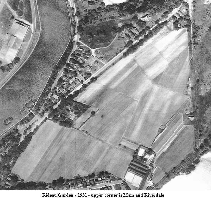
was one of the first settlers in the area arriving in 1817. Working 60 improved acres with 3 acres in pasture and 10 in gardens/orchards, he produced 350 bu. of oats, 30 bu. of peas, 50 bu. of corn, 700 bu. of potatoes(on 6 acres), 12 tons of hay and 30 bu. of fruit (pears, plums, other fruit) and 50 lbs. of butter. Livestock included: 3 horse, 5 milk cows, 3 pigs and 14 hives of bees. Firewood cut totalled 45 cords. The farm consisted of 1 dwelling house, 3 barns/stables, 2 carriages/sleighs, 2 cars/wagons/sleds and 1 pleasure/common boat. Williams, born in England, was 64 in 1871. His wife Oreilla, born in the United States was 52. Lewis fathered 7 children: Lewis Jr. (26 – farmer), David (24 – farmer), Mary (18), Martha (16), Caroline (14), Francis (11 – male) and Harriet (8). Another child, Daniel? Johnston, age 3 and born in the United States, lived with the family. Perhaps this child was kin to his wife. There is much more on this very interesting family in the Notables Section. The original farmland still existed in the 1930’s as shown by this air photo taken in 1931. Robert Lees was one of the most important figures in the Ottawa East community, Listed in the 1871 Census as a county attorney, from his holdings and agricultural activities it appears that he was also a very successful farmer.
Along with his legal work and farming activities, Lees was a major land speculator. Schedule 3 of the 1871 Census indicates that he owned 870 acres, with 24 building lots, 4 dwelling houses and 2 barns/stables. Born in Scotland, he was 54 in 1871 and along with his Ontario born wife
Jessie, aged 46, had 5 In total, it appears that Lees was involved in many pursuits, which provided for a privileged lifestyle for his family. His fascinating life is chronicled in the Notables Section, which includes an extensive collection of family writings and very early photographs. Barrels, Bricks and Civil Servants The northern part of the Ottawa East community, as noted earlier, was a combination of industries, agricultural activities and residences. To identify specific people living in this part in 1871 has been made difficult in that the original enumerator seems to have relied on some as-yet-unknown system of identifying some lots in Conc. C and D. The actual boundary of the enumeration districts have been lost to time. The available directories of residents, which begin in 1864, are incomplete in that these were commercial endeavours and not that concerned with gathering all the information. In an attempt to remedy this confusion, information from the directories and the 1871 and 1881 censuses have been cross-referenced. For example the first detailed directory of Archville appeared in 1877 and therefore it has been assumed that some of the people listed here were also present at the same locations (or nearby) prior to 1877. What follows therefore is an overview of the northern part of Ottawa East relying heavily on the 1877-81 Archville directories (see table here) and the census material. The Archville directories for this 5-year span show 37 employment ‘types’.
This is approximate in that certain related jobs have been grouped together.
For example, a gas fitter is considered to be a plumber. Given this there
were 133 people listed as employed in this 5-year period. Of this 29 worked
as labourers (21.8%), 15 in the civil service (11.2%) and 11 carpenters
(8.2%). It is interesting to note that when It is clear therefore that Ottawa East in the decade 1871-81 was predominantly blue collar. The table here shows the actual job descriptions over the 5-year period of 1877 to 1881. The 1871 census in Schedule #6 lists 7 industrial establishments in Sub-district A-1, which includes Ottawa East. The list includes 2 brick manufacturers, 2 breweries, a blacksmith, a tannery and a weaving shop. Of these the largest and only one positively identified as being in Ottawa East was the brick making business of O’Dell. The two breweries, owned by the Rochester family, were probably located in Conc. Lot I situated to the west of the canal and therefore not part of Ottawa East. Horace C. O’Dell (also Odell), born
in the United States about 1818 of German origin, he emigrated In 1871, O’Dell produced 1,500,000 bricks for an aggregate value
of $9,000. These figures appear in O’Dell owned 10 acres with 6 improved in Conc. D. The land records indicate that the family also owned land in Conc. C in the name of his wife Adeline. He had 6 acres in pasture and half an acre in garden/orchard. The pasture was used to feed his 5 horses and 1 cow to feed his family. There was 1 dwelling house, 2 carriages/sleighs, I wagon/sled and 1 plow/cultivator. There is more on this man in the Notables Section found here.
Footnotes: For complete references, see the Sources section.
|
| Go to Chapter
Four |
|


