
| Project Information |
| History |
| Mainstreeter |
| Churches |
| Scholasticate |
| Schools |
| Railways |
| Notables |
| After 1907 |
| 1901 Snapshot |
| Air Photo Study |
| Image Library |
| Databases |
| Search |
|
Bricks, Bricks and
more Bricks
|
| It is hard to imagine Ottawa East as being rich in mineral resources but
that is in fact the case. From the 1870's to the early 1930's, the rich
clay and sand deposits found along the western edge of the Rideau River
were the main source of raw material for the production of brick and drainage
tile. This resource attracted men such as Horace O'Dell, John Graham and
John Cain to the area and resulted in the establishment of large brickworks
at the end of Lees Ave and Clegg St.
The story begins about 13,000 years ago with the end of the Wisconsin
glacial period. |
| There are five different materials found at the surface along the banks of the Rideau River including bedrock, glacial till, silty clay, alluvial sand and fill. Glacial till is sand, gravel and silt carried by the ice and left in unstratified and unsorted deposits upon melting. Silty clay is comprised of fine particles laid down in standing water. Alluvial refers to deposits from moving water. In general, a deep layer of silty clay covered by fine alluvial sand is found in the Ottawa East area. It is this material that is ideal for the production of clay brick. | |
| Making Brick:
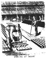
The brickmaking process utilized in the 1870's involved five steps beginning with the removal of overlying sand to expose the clay deposits. This was done in the fall as it allowed the freeze-thaw cycle in winter to break the clay down, making it softer and removed unwanted oxides. This process is called "winning" or mining the clay. The next step involved grinding the clay into powder and screening the
material to remove Moulding came next. Here a "clot" moulder would form a lump and pass it to the brick moulder. He would roll it in sand and then "dash" it into a sand-covered mould and remove the excess with a strike (a water-soaked flat stick). Sand was used to prevent sticking to the mould. A team of moulders; working 12 to 14-hour days could make up to 5,000 bricks in a day. These bricks were referred to as "sand struck" or "slop moulded" bricks. |
|
 |
 |
|
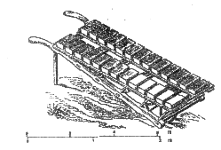
The moulded brick was taken to the drying area on a pallet or barrow. Stacked in a herring bone pattern on a level bed of sand, the bricks were left to dry for 2 days and then turned. During this time "edgers" used tools to straighten and smooth the bricks. After 2 more days they were turned on end stacked in a hack (or hackstead) with a fingers width between them and left to dry for two weeks. The final step involved "burning". Here "clamps"
or "scove kilns" were built with the raw brick. Wood and All that was left to do was to sort the brick. The slightly underfired
brick was salmon in colour and used for inside walls with the best brick
used for exterior work. |
|
| O'Dell Brickworks:
The 1871 Census (Schedule #6) offers a detailed view of early brick production at the O'Dell Brickworks located on Lees Ave. approximately near the corner of Simcoe St. The first local record of Horace O'Dell appears in the Nepean Assessment Roll of 1865. He is listed as a brick manufacturer along with an Amos O'Dell. The 1881 Census indicates that Horace was born in Germany immigrated to the United States and then moved to Canada. In 1871 he made 1,500,000 bricks with an aggregate value of $9,000. To do this he mined 3,000 cubic yards of clay and used 300 cords of wood for the kiln. The work was seasonal (only 5 months) and employed 15 men and 5 boys at a total wage cost of $2,000. From the municipal directory it appears that the O'Dell Company was no longer in business by 1910 and there is no reference on the fire insurance maps for that time period. The land record show that the family sold their land in Concession D, Lot G about that time. A remnant of the brickwork's excavations can be seen here in this 1928 air photo that shows one of the clay pits. There is more on Horace O'Dell here including two topographic maps showing the location of the brickyard. |
|
| Graham Brickworks:
John Graham owned the next oldest brickworks in Ottawa. The Ontario Land Records show that he leased land in Concession D, Lot I in 1882. A subsequent 1885 lease (Instrument #10485) extended his right to excavate clay "for the purpose of making brick". The lease description suggests that most of the excavation took place in the area of present-day Brantwood Beach with Clegg St. as the main point of entry. John funded the operation but had little to do with the day-to-day operation
as this was left to his stepson By 1907 Alexander Graham was listed as a cement block manufacturer. The next year the Cain Brick Company appeared at 161 Main St. This is more than coincidental in that John P. Cain was part owner of the land originally leased to Graham. When the ten-year lease ran out Cain established his own brickyard. The Fire Insurance Map for this time period here shows Cain located east of Main near Clegg St.. By 1917 Cain was no longer listed in the directory. There is more on John Graham here. |
|
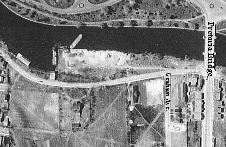
| Silicate Brick Company:
The Silicate Brick Company first appeared in the 1904 directory. It was
located on the west side of East Ave. (Echo Drive) across from where St.
Patrick's College would be built. As the areal photo shows below, the
plant itself was built on reclaimed land that extended into the canal.
Pictures of the plant shown below indicate that large canal barges regularly
tied up to the adjoining wharf. |
|
 |
|
 |
 |
| The location was ideal for several reasons. Silicate brick is made from sand, lime and water that has been agglomerated (mixed), compacted and cooked under pressure for several hours. This produces a very hard, durable crystalline brick. The canal provided a ready supply of water and transportation for the large quantity of sand required. The sand was obtained from the "Uplands Sand Pits" located upstream near the present-day Hunt Club Bridge. With the help of Col. By's canal system, barges were loaded and sailed downstream to Mooney's Bay where they were locked down into the canal. Many older residents of Ottawa East recall massive piles of sand along the canal at the brickworks in the 1920's. The Fire Insurance Map of that time period shows the detail of the plant and indicates that 44 men were employed. To see the map go here. | |
| For a brief time a railroad siding connected the plant to
the main line just east of the canal. The lease for this siding was cancelled
in 1915 when the Pretoria Bridge was built. A picture of the siding is shown
here.
By the 1921 the company had become the Foster and Cram Company. Production continued through the 1920's and by the early 1930's the company had moved to another location. Given the federal government's penchant for beautifying the canal lands it is a wonder that brick production by the canal lasted that long. Today Echo Drive is situated on the brickwork's land. The closing of the silicate brick plant was the end of an era in Ottawa
East that began in the mid-1860's with the arrival of Horace O'Dell. It
was also the last time there was a large-scale industrial production in
the community. And finally, it marked the end of the canal's economic
usefulness to Ottawa East. The legacy lives on however, in that the millions
of bricks produced were used to build Ottawa. |
|
|
Sources: |
|
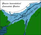 With the retreat of the glacial ice, huge meltwater lakes were created
including the Champlain Sea. As the water levels receded, drainage channels
such as the Rideau River were created. The sedimentary deposits left by
this recession later became the basis for Ottawa East's first industry.
With the retreat of the glacial ice, huge meltwater lakes were created
including the Champlain Sea. As the water levels receded, drainage channels
such as the Rideau River were created. The sedimentary deposits left by
this recession later became the basis for Ottawa East's first industry. stones.Sometimes
it was placed in soaking pits to obtain the correct consistency for moulding.
It then had to be kneaded to mix all the clay elements together. Called
tempering or pugging, it was done by hand until about the 1850's when
the horse driven pug mill came into use.
stones.Sometimes
it was placed in soaking pits to obtain the correct consistency for moulding.
It then had to be kneaded to mix all the clay elements together. Called
tempering or pugging, it was done by hand until about the 1850's when
the horse driven pug mill came into use.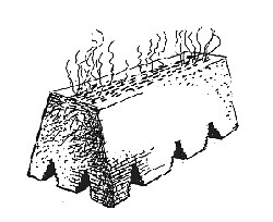 coal were used to produce a low heat for a slow drying time of 24 to 48
hours. During this time "water smoke" or steam could be seen
rising from the kiln. When this ceased the intensity of the fire was increased
to 1800 F. for a week. At this point the fire holes were bricked over
and the heat allowed to dissipate for another week.
coal were used to produce a low heat for a slow drying time of 24 to 48
hours. During this time "water smoke" or steam could be seen
rising from the kiln. When this ceased the intensity of the fire was increased
to 1800 F. for a week. At this point the fire holes were bricked over
and the heat allowed to dissipate for another week.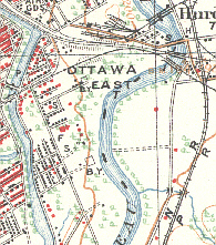 Alexander. The earliest directory reference in 1890-91 under the name
of Gamman (Thomas) and Graham (Alexander) on the macadamized road (Main
St.). In 1896, the year John died, Alexander signed a ten year lease (Instrument
#17333) that permitted further clay excavation for the production of bricks
and drainage tile to a limit of "3,500,000" units. The map to
the right shows the location of the brickyard (B.Y.) at the end of Clegg
St. beside the river.
Alexander. The earliest directory reference in 1890-91 under the name
of Gamman (Thomas) and Graham (Alexander) on the macadamized road (Main
St.). In 1896, the year John died, Alexander signed a ten year lease (Instrument
#17333) that permitted further clay excavation for the production of bricks
and drainage tile to a limit of "3,500,000" units. The map to
the right shows the location of the brickyard (B.Y.) at the end of Clegg
St. beside the river.